Showing posts with label houses. Show all posts

Thursday, September 1, 2016

2016 Thursday, September 1, Corinth during and after the Civil War

A day trip to Corinth, MS. 
Our first stop was 1551 Horton Street at the Corinth National Cemetery, which was established in 1866, as a central burial site for approximately 2,300 Union casualties of the Battle of Corinth.
Many of the tombstones are unknown (represented by a number)  Soldiers represented by 273 different regiments from 15 states. The cemetery is well kept with rows and rows of white tombstones. We saw “An Act” as a marker to establish and protect National Cemeteries. 
We also saw a marker addressed by President Lincoln at the dedication of “the Gettysburg National Cemetery” on November 19, 1863.
There were several large trees throughout the cemetery.

A marker with a poem
From the Bivouac of the Dead
by Theodore O’Hara
The muffled drum’s sad roll has beat 
The soldier’s last tattoo;
No more on life’s parade shall meet
That brave and fallen few.
On Fame’s eternal camping-ground
Their silent tents are spread,
And Glory guards, with solemn round,
The bivouac of the dead. 
Corinth National Cemetery 
A National Cemetery System
Civil War Dead
An estimated 700,000 Union and Confederate soldiers died in the Civil War between April 1861 and April 1865. As the death toll rose, the U. S. government struggled with the urgent but unplanned need to bury fallen Union troops. This propelled the creation of a national cemetery system.

On September 11, 1861, the War Department directed commanding officers to keep “accurate and permanent records of deceased soldiers.” It also required the U. S. Army Quartermaster General, the office responsible for administering to the needs of troops in life and in death, to mark each grave with a headboard. A few months later, the department mandated the interment of the dead in graves marked with numbered headboards, recorded in a register.

Soldier’s graves near General Hospital, City Point, Va. c1863. Library of Congress

Creating National Cemeteries
The authority to create military burial grounds came in an Omnibus Act of July 17, 1862.
It directed the president to purchase land to be used as “a national cemetery for the soldiers who shall die in the service of the country.”
Fourteen national cemeteries were established by 1862.
When hostilities ended, a grim task began. In October 1865, Quartermaster General Montgomery C. Meigs directed officers to survey lands in the Civil War theater to find Union dead and plan to reinter them in new national cemeteries. Cemetery sites were chosen where troops were concentrated: camps, hospitals, battlefields, and railroad hubs. By 1872, 74 national cemeteries and several soldiers’ lots contained 305,492 remains, about 45 percent were unknown. 

Knoxville was established after the siege of the city and the Battle of Fort Sanders in 1863. Cemetery plan,1892, National Archives and Records Administration. 

Lodge at City Point, Va., pre-1928. The first floor contained a cemetery office, living room, and kitchen for the superintendent’s family; three bedrooms were upstairs. 

Most cemeteries were less than 10 acres, and layouts varied. In the Act to Establish and Protect National Cemeteries on February 22, 1867, Congress funded new permanent walls or fences, grave markers, and lodges for cemetery superintendents.
At first, only soldiers and sailors who died during the Civil War were buried in national cemeteries. In 1873, eligibility was expanded to all honorably discharged Union veterans, and Congress appropriated $ 1 million to mark the graves. Upright marble headstones 
honor individuals whose names were unknown; 6-inch-square blocks mark unknowns.
By 1873, military post-cemeteries on the Western frontier joined the national cemetery system. The National Cemeteries Act of 1873 transferred 82 Army cemeteries, including 12 of the original 14, to what is now the National Cemetery Administration. 

Reflection and Memorialization 
The country reflected upon the Civil War’s human toll-
2 percent of the U. S. population died. Memorials honoring war service were built in national cemeteries. Most were donated by regimental units, state governments, and veterans’ organizations such as the Grand Army of the Republic. 
Decoration Day, later Memorial Day was a popular patriotic spring event that started in 1868. Visitors placed flowers on graves and monuments and gathered around rostrums to hear speeches. Construction of Civil War monuments peaked in the 1890s. By 1920, as the number of aging veterans was dwindling, more than 120 monuments had been placed in the national cemeteries.
National cemetery monuments left to right: Massachusetts Monument, Winchester, Va., 1907; Maryland Sons Monument, Loudon Park, Baltimore, Md., 1885;  Women’s Relief Corps/Grand Army of the Republic Monument to the Unknown Dead, Crown Hill, Indianapolis, Ind., 1889.
 Benjamin Franklin  Liddon Home 
 Benjamin Franklin  Liddon Home 
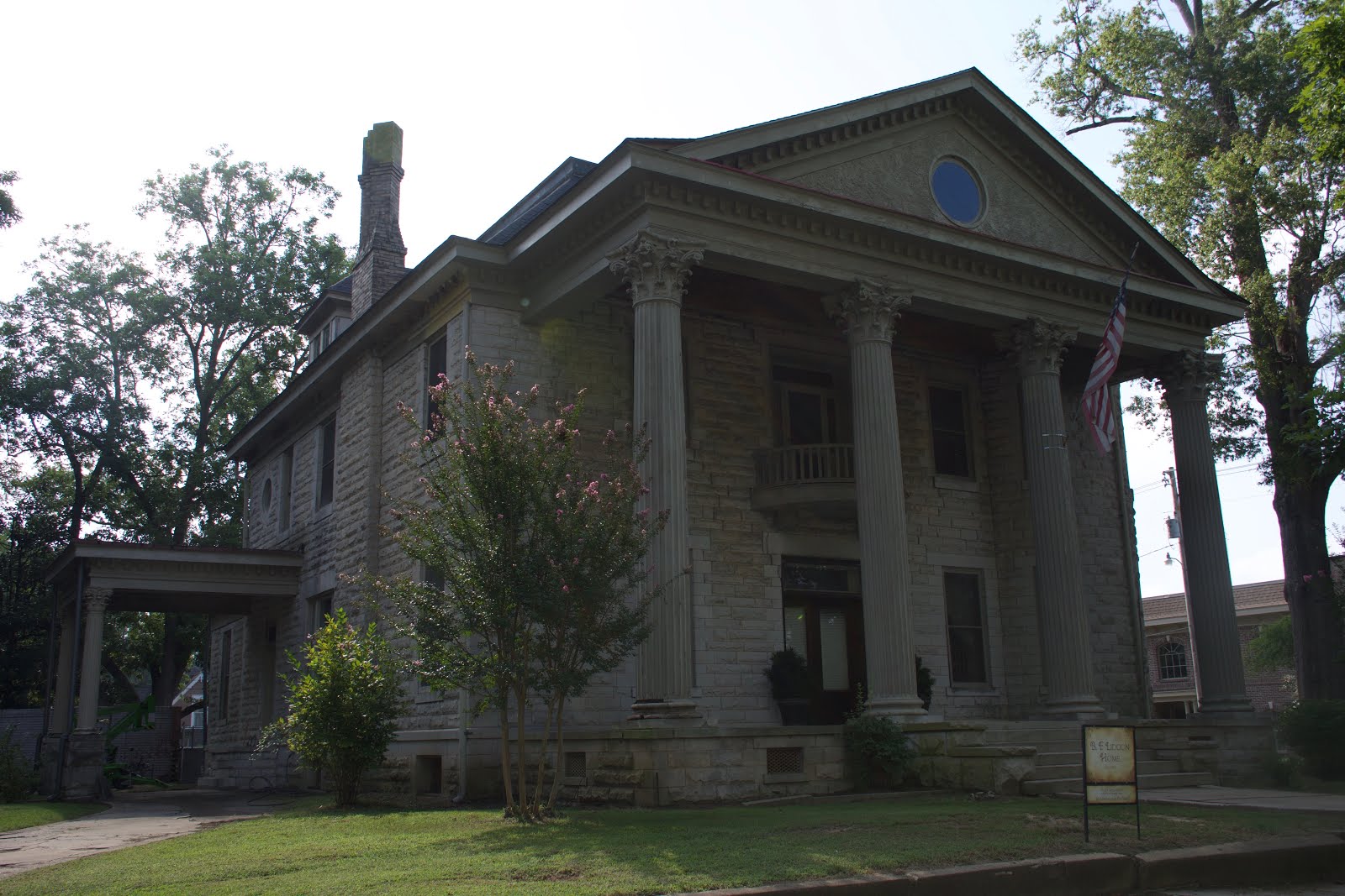
We rode past the Benjamin Franklin Liddon Home (called the Cat House) build circa 1907, which was under renovation by Richie and Margret Mathis. 
This castle home is located at the corner of Webster and Bunch streets. 
Mr. Liddon was an eccentric businessman and an architect who loved motion pictures and wanted to bring entertainment to the area. 
The castle-like home has Corinthian columns, imported from New York, intricate stonework, and turrets (an eye-catcher).

 Fillmore Church, Corinth’s oldest church
We stopped at the  Fillmore Church, Corinth’s oldest church. It was erected in 1871 by Cumberland Presbyterian Church. The building was constructed of load-bearing red brick walls (faded over time) and windows with lancet arches. The main steeple is attached to the front facade of the building with a red slate, and triangle roof. 


Site of Rose Cottage
The site of Rose Cottage was facing the  Fillmore Church. 
The Rose Cottage was the headquarters for Confederate General Albert Sidney Johnston, who had received a fatal wound at the Battle of Shiloh. 

I walked up the street to the Oak Home, where I took several pictures. 

Judge W. H. Kilpatrick of Corinth had Oak Home built in 1857 by Tom Chesney, a local house designer, and builder. Mr. M. S. Miller, a civil engineer working in Corinth shortly before the war, made this sketch in 1860, the only known Civil War vintage picture of Oak Home. Miller notes that a wood fence surrounded the whole block and that the “fine house” was straw-colored with a yellow door bordered by sidelights. 
Also, a green magnolia plaque marker was located in front of the Oak Home, located at 808 N Fillmore Street. 
The house had a black shingle-hipped roof, with two chimneys, a triangle-covered porch an entrance with white siding, and was surrounded by a white picket fence. 

OAK HOME
Built in 1858 for Judge W. H. Kilpatrick. Used in Civil War as headquarters of General Leonidas Polk. Bought in 1866 by Mrs. Thomas Quincy Martin and occupied continuously by her descendants. 

Curlee House built in 1857 
Our next stop was the corner of Jackson and Childs Streets to tour the Curlee House built in 1857 an example of Greek Revival. The restored home contains eighteenth and nineteenth-century paintings, antiques, and  Civil War memorable. 
The house was a one-story mansion with high ceilings and mural walls in the hallway. It had a kitchen, dining room, and two bedrooms. Both front rooms had floor-to-ceiling mirrors, fireplaces with huge wooden mirrors above the fireplace, with crystal chandlers hanging from the ceiling. 

 Mathushek Piano
There was a Mathushek Piano manufactured in New Haven, Ct, patented June 24, 1894, sitting in the hallway.
Mathushek was one of the greatest innovators in piano design. He established his firm in 1863, and he built his pianos in partnership with Driggs. He moved his firm to New Haven, Ct in 1866. He built a line of square grand that was very different from their contemporary competitors. These square pianos were known as the Colibri and the Orchestral models. The piano in the hallway was an Orchestral model. Opened and displayed above the keys was the song, “Beautiful Star of Heaven”. 

Curlee House Marker 
One of Corinth's founders, surveyor Hamilton Mask, built this Greek Revival home in 1857, pictured above as it appeared about 1862. It became known as the "Verandah House" because of its porches and served as headquarters for both Union and Confederate officers. William P. Curlee, whose name it now bears, bought the property in 1875. Except for minor changes, it appears today much as it did in 1862. You are invited to tour the house during its open hours.

During the war high-ranking officers customarily occupied private homes for use as dwellings and headquarters. The generals pictured above occupied the Curlee House at different times in 1862.

Gen. Braxton Bragg, CSA, Gen. John B. Hood, CSA, Gen. Henry W. Halleck, USA

We walked outside where we saw a small vegetable garden, flower gardens, sitting area, restrooms, and the Verandah House 1857. 
The building to the left in the photograph is believed to have been the kitchen for the Verandah House 1857. Kitchens in the 19th century were often outside structures due to the danger of fire as cooking was done in an open fireplace. Homes in this period, of necessity, were largely self-sufficient  Outside utility buildings included kitchens, stables, carriage houses, smokehouses, spring houses, and privies were needed to house these various activities. Many of the outbuildings were conveniently located in close conjunction with the main house and as a result,  became important elements in the design of the grounds and gardens. 

Fresh vegetables, herbs, fruit trees, and flowers were often grown near the kitchen. Summers are spent canning and picking many of the harvested fruits and vegetables. Herbs were used as flavorings and for various medicinal purposes. Some of the plants and flowers grown in the Verandah House kitchen garden were favorites of Stephanie Sandy and most were favorites during the 19th century too.

Three sides of the house had an outside entrance, and there was a basement on the backside of the house.

On the side of the house without an outside entrance, facing a white siding house that reminded me of the Amityville Horror House. 
Would not want to have them as neighbors. 
Amityville Horror House in Corinth 
Amityville Horror House
Abe Reubel House
Our next stop was outside the Abe Reubel House, 1109 Jackson Street built in 1904 in the Neoclassical style, with Georgian Revival influences. It had three bailed dormers on the roof, each with cornice returns. 
The central dormer had a Palladian window. 

 B&B Generals Quarters Inn, 924 North Fillmore Street. 
We saw the finely restored 1872 grand Victorian home in historic Corinth, called the B&B Generals Quarters Inn, 924 North Fillmore Street. 

 Waldron Street Christian Church
We stopped to take a picture of the Waldron Street Christian Church built to compliment the style of the original church built in the 1900s.

We rode downtown stopping for lunch at Borroum’s Drug Store and Soda Fountain. 
Hubby ordered a cheeseburger with onion rings. I wanted to try the Slug burger, served with onions, lettuce, tomatoes, mustard, and a bag of baked chips. 

The Slug Burger is a patty made from a mixture of beef or pork and an inexpensive extender such as soybeans, it is deep-fried in oil.
According to town legend the term “slug burger" comes from the slang term for a nickel. 

Slug Burger
Reading the history of the Slug Burger
Ordering the Slug Burger
Camille Barroom Mitchell the pharmacist
The soda and Ice Cream Counter
Paying tab and purchasing a cookie 

'https://video.search.yahoo.com/search/video;_ylt=AwrBT7o9KcxXcB8AeBZXNyoA;_ylu=X3oDMTEyaDkyMWp1BGNvbG8DYmYxBHBvcwMxBHZ0aWQDQjE3OTNfMQRzZWMDc2M-?p=Borroum%27s+Drug+Store+Utube&fr=aaplw#id=3&vid=aeda1d252f5847afb74b9072b2f442aa&action=view

Borroum Drug Store is Mississippi’s oldest drug store established in 1865 and still in the family. Camille Barroom Mitchell the pharmacist is the great-granddaughter of Doctor A. J. Barroom, who started the store after the Civil War in 1865.
Met this sweet lady, she was reading the new paper, and looking at the ads. She was talking about the price of something is $12.99 and though the price might go down it went up instead. 
Camilla was sitting at a table across from us, she talked to us, while I ate my slug burger. 
Everyone we met at the Drug Store was friendly and the food was good. I know the next time we are in Corinth that we will be going back for a visit. 
I want to try their cornbread salad. I watched as one of the waitresses make the cornbread salad for a couple sitting behind us. 
First, she crumbled up a handful of cornbread, followed by a large dipper full of hot chili, next to a couple hands full of lettuce, tomatoes, shredded cheese, and topped with Jalapeños peppers.  

We walked up front to pay, cash only! On the counter was a cake plate full of cookies.
There was oatmeal, chocolate chip, Macadamia and oatmeal-raisin, chocolate with coconut cookies. 
We bought one of the oatmeal raisins with coconut and chocolate cookies. 

We rode to the Corinth Civil War Interpretive Center. We saw many items found during the Civil War that had been placed on the concrete sidewalk. We saw canteens, belt buckles, shells, bullets, hats, food pails, shovels, a gun, rifles, and other items. 
At the entrance to the wall was a bronze plaque of six Confederate Soldiers carrying rifles. 
Inside we were greeted by a National Park Ranger. He said we could watch a film in about twenty minutes and in the meantime, we could tour the museum. FREE!!
We walked outside to see a couple of canons and a flowing fountain with different battle sites during the Civil War. 

Bronze plaque of six Confederate Soldiers
Corinth was the beginning of freedom
Last we watched a ten-minute film about the Civil War. 
We bought hamburger meat, and shrimp at Foodland for supper. 

We had a great day, saw many sites, and learned some history about Corinth during and after the Civil War. 
Traveling Home 


Monday, June 27, 2016

Historic Markers of Norfolk Virginia

Commercial  Place Norfolk VA ~Commercial Place & East Main Street Norfolk, Virginia 
When a survey was done in 1680 to lay out the town of Norfolk, one of the few streets shown was “the street that leads to the waterside.” The original location was just to the west of this site. It fanned out from Front (now Main) Street south to the Elizabeth River. As the new town developed, this area became its commercial hub. When a market was built here near Front Street in the early 1700s the area became known as Market Square. At the river’s edge, a ferry dock and commercial wharves developed. About 1900 the name changed again, to Commercial Place. This illustration “Old Norfolk Evening” by artist John Morton Barber, recreates the southern end of Market Square/Commercial Place in 1887. Double-edged steam ferries shuttle back and forth across the Elizabeth River to Berkley and Portsmouth. The English ship Carnarvonshire is being towed into the harbor to load goods for her voyage across the Atlantic, and the side-wheel steamer Luray is carrying passengers downstream toward Town Point.
Commercial  Place
Epworth United Methodist Church 1894 ~124 W. Freemason Street Norfolk, VA
Epworth United Methodist Church, 1894 
This 1894 Richardsonian Romanesque granite and sandstone church was designed by Norfolk architects James E. R. Carpenter and John V. Peebles. It was built to accommodate the growing congregation of the 1850 Granby Street Methodist Church at the Northeast corner of Granby and Freemason Streets. Both churches originated from the 1802 Cumberland Street Methodist Church, the first Methodist congregation in Norfolk. 
The congregation named their new house of worship "Epworth" after the English home of John Wesley, the founder of Methodism. Gothic features on the 135-foot carillon tower include eight gargoyles. In the sanctuary, a stained glass dome designed by Edward J. N.  Stent of New York is supported by arches bearing mosaic likenesses of female figures representing the cardinal virtues of faith, hope, love, and charity. The Aeolian-Skinner organ was considered to be the finest in the South at the time of its installation in 1959. 
Epworth members organized Norfolk's first chapter of Goodwill Industries and the city's first Circle of the King's Daughters. They also participated in the establishment of Virginia Wesleyan College. 
City of Norfolk
Epworth United Methodist Church, 1894 
Four Farthing or Town Point Granby St. near East Main StreetNorfolk
Four Farthing or Town Point
Here at a cedar tree was the western limit of the fifty acres constituting the original Town of Norfolk. The land was bought in 1682 as a port for Lower Norfolk County from Nicholas Wise, Jr for "ten thousand pounds of tobacco and casket." It was deeded to Captain Wm. Robinson and Lt. Col. Anthony Lawson as Feoffees in trusts for the county.
Owen Foundry Mfg. Company Inc Norfolk VA
Four Farthing or Town Point
Freemason Street Baptist Church Northeast corner of Freemason and Bank Street Norfolk
Freemason Street Baptist Church 
In May 1848 former members of Cumberland Street, Baptist Church organized to become the Freemason Street Baptist Church. A new church building was begun that year and completed and dedicated in May 1850. The Reverend Tiberius Gracchus Jones, a noted author, and preacher was the church's first pastor. Thomas Ustick Walter (1804-1887) of Philadelphia, one of the most prominent architects of the mid-19th century, designed the Gothic Revival structure. In Norfolk, Walter also designed the Norfolk Academy building (1840) and consulted on the dome for the City hall and Courthouse (1850). He later gained fame as the architect of the massive dome of the U. S. Capitol. With its original steeple, higher than the present one, Freemason Street Baptist Church was the tallest structure in Norfolk from 1850 to 1879. During a severe storm in August 1879, the steeple was blown off and landed on Freemason Street. It was replaced with the present steeple in 1897. The church building is included on the National Register of Historic Places. City of Norfolk

Freemason Street Baptist Church 
Governor Tazewell W. Tazewell Street West of Granby Street Norfolk
Here stood the residence of Littleton Waller Tazewell, attorney, Virginia legislator, U. S. Congressman, Senator, and Governor of Virginia. The Williamsburg native came to Norfolk in 1802 to practice commercial and maritime law and was widely known for his skill in debate. He successfully negotiated with the British against their blockade of Norfolk in 1807, helped finalize the purchase of Florida from Spain in 1821, and participated in the 1829 Convention to rewrite Virginia's Constitution.
Tazewell declined Henry Clay's invitation to serve as running-mate in Clay's unsuccessful bid for President in 1828 and President Andrew Jackson's offer of a post as Secretary of War or Minister to Great Britain. He received 39 votes from the Electoral College in the 1836 presidential election, even though he was not a candidate. That Littleton Waller Tazewell's reputation was not more lasting is attributed to his distaste for politics and dislike of being separated from home and family.
Tazewell's home was moved to Norfolk's Edgewater neighborhood around 1900. It is on the National Register of Historic Places. City of Norfolk
Governor Tazewell W. Tazewell 
Granby Street ~Granby Street between Main & Plume Streets Norfolk
Granby Street 
Granby Street was named in 1769 to honor Englishman John Manners (1721-1770), Marquess of Granby. The original street ran three blocks from Bute Street south to Town Back Creek, a semi-navigable stretch of marshland running the length of today's City Hall Avenue. Town Back Creek was a barrier to development in the northern portion of the Borough until a bridge was built in 1818 to span the creek at Granby. As it became more accessible, Granby Street was transformed into a residential area of stately homes. 
The electric streetcar debuted in Norfolk in 1894, and neighborhoods were established along the route. Many Granby Street residents moved to the new suburb of Ghent, and businesses of every kind replaced their former homes. By 1910, Granby surpassed Main Street as Norfolk's busiest shopping district. From 1976 to 1986 part of Granby was closed to vehicular traffic and renamed Granby Mall. Granby Street declined through the 1990s, but with the opening of Tidewater Community College and MacArthur Center, it has been revitalized with residences, theaters, and restaurants.  City of Norfolk
Granby Street
James W. Hunter House 1894 ~240 West Freemason Street, Norfolk, VA
James W. Hunter House, 1894 
James Wilson Hunter (1850-1931) was a prominent Norfolk merchant, banker, and civic leader. In 1894 he commissioned Boston architect W. P. Wentworth to design and build this impressive townhome for his family on West Freemason Street. The design represents the Romanesque Revival style of architecture made popular by noted architect Henry Hobson Richardson in the late 1800s. James and his wife Lizzie Ayer Barnes Hunter had three children. None of the children married and all lived out their lives in this house. James W. Hunter, Jr (1878-1940) served as a medic in World War I and was later a noted physician specializing in the fields of cardiology and radiology. The Hunter sisters, Harriett Cornelia (1880-1958) and Eloise Dexter (1885-1965) were very active in local, state, and national patriotic and genealogical societies. As the last surviving member of the family, Eloise left her family home and its collection to be used as a museum of Victorian architecture and decorative arts. A foundation created by her estate refurbished the house and administers the museum today. City of Norfolk
James W. Hunter House, 1894 
Littleton Waller Tazewell Lawyer
On this site stood the residence of Littleton Waller Tazewell 1774-1860 Lawyer Congressman US Senator Governor of Virginia his life was spent in the service of his native Virginia
Littleton Waller Tazewell Lawyer
Main Street Norfolk Va ~ East Main St & Martin's Ln, Norfolk, VA hanging on Marietta Building
Main Street 
In his 1680 survey of the site that was to become the Town of Norfolk, Lower Norfolk County surveyor John Ferebee laid out the principal street along a ridge of highland extending from Foure Farthing Pointe (Town Point Park) to Dun-in-the-Mire (Harbor Park). Originally called Front Street, it is now Main Street. The first house was built by mariner Peter Smith in 1683 on a lot at the Southwest corner of Main Street and Market Place. The county courthouse was located on the north side of the street in 1694. Main Street today follows its original corridor. The street was widened in 1782, trolley cars were introduced in 1894, and Belgian block paving was installed in 1897. Throughout its history, Main Street has been the center of community activities in Norfolk. Following a period of decline and the "Honky Tonk" era of World War II, the redevelopment of the 1960s through the 1990s has returned Main Street to its traditional role as the economic heart of the city. City of Norfolk
Main Street 
Margaret Douglass~East City Hall Avenue, between Monticello Avenue and Granby Street Norfolk
Margaret Douglass 
Margaret Douglass, a white woman from Charleston, South Carolina, moved to Norfolk with her daughter Rosa in 1845 and lived near here on the former Barraud Court. She was a vest maker by occupation. In June 1852 she and her daughter opened a school in the second-story back room of her house to teach 25 free black children, both boys and girls, how to read and write. Tuition was three dollars a quarter. After she was seen walking in the funeral procession of one of her deceased students, her school was raided, and she was arrested. She argued her own case in court, pointing out that the wives and daughters of several court officials taught black children weekly in Sunday School classes at Christ Church from the same books she used. After being on her booklet about her experience in Norfolk that was published in 1854. City of Norfolk
Margaret Douglass 
Monticello Hotel 1898
Corner of City Hall Ave & Granby St, Norfolk, VA 23510
The Monticello Hotel, which opened at the corner of City Hall Avenue and Granby Street on September 27, 1898, was the largest and finest hotel in Norfolk for over 60 years. By 1885 Town Back Creek had been filled to Granby Street. Construction of the hotel spurred additional development along the new City Hall Avenue. The hotel suffered a devastating fire on January 1, 1918. In addition to the flames, firefighters had to deal with bitter cold and ice. When it reopened in 1919, two additional floors had been added, including a large dining room and horseshoe-shaped ballroom known in later years as the Starlight Room. This became a favored location for balls, dances, and community events. The grandly appointed mahogany bar doubled as a billiards parlor during Prohibition. During the 1933 hurricane, the hotel and a broad area of downtown suffered considerable flood damage. The Monticello Hotel was the first building in Norfolk to be imploded in January 1976 to make way for the Norfolk Federal Building now on this site.
Monticello Hotel 1898
Moses Myers House 1792 - 323 East Freemason Street Norfolk Va
Moses Myers House, 1792 
Moses Myers (1753-1835) was a shipping merchant who came to Norfolk in 1787 from New York. He acquired this site in September 1791 and built his distinguished Federal townhouse in 1792. It was one of the early brick buildings to be constructed in Norfolk after the destruction of the town during the Revolution. The distinctive dining room and kitchen were built about 10 years later. In addition to his shipping business on Market Square, Myers became the superintendent of the Norfolk branch of the Bank of Richmond. He was active in public affairs as well, holding diplomatic positions in Denmark in 1812 and in Holland in 1819. In 1828 he was appointed Collector of Customs for Norfolk by President John Quincy Adams. The Myers family continued to own and occupy the house until 1931. The house welcomed many distinguished visitors over the years including Stephen Decatur, the Marquis de Lafayette, James Monroe, Henry Clay, General Winfield Scott, President William Howard Taft, and President Theodore Roosevelt.  City of Norfolk

Moses Myers House, 1792 
Norfolk College for Young Ladies ~College Street & Granby Street Norfolk
On this site was the Norfolk College for Young Ladies, which was chartered on February 20,1880 with Capt. John L. Roper as President of the Board. The school was designed by James H. Carlow, one of Norfolk's leading architects at the time. It opened that year with 125 students. The school offered educational opportunities for young women both in traditional academic subjects and in such social refinements as music, drawing, deportment, elocution, and "mental and moral science." When the public school expanded programs for women, the College closed. Its last class graduated in 1899. An active Alumnae Association supported your Norfolk women with grants and scholarships for many years. College Place, originally Green Bush Street and later Washington Street, was named for the College in the mid-1880s. The building became the Algonquin Hotel in 1905, in time to accommodate visitors to the Jamestown Exposition. The name was changed to Hotel Edwards in 1918 and to Hotel Lee in 1936.
The name was changed to Hotel Edwards in 1918 and to Hotel Lee in 1936.
Stores occupied the first floor until the building burned and was demolished in 1983. City of Norfolk

Norfolk College for Young Ladies
Old City Hall and Courthouse, 1850~Bank Street & City Hall Avenue Norfolk
When Norfolk became an independent city in 1845, space was needed to accommodate municipal functions. The Classical Revival building was begun in 1847 and completed in 1850 as Norfolk's City Hall and Courthouse. The architect was William Singleton, a Portsmouth native then practicing in St. Louis. He was assisted, particularly in the design of the dome, by Thomas Ustick Walter, a Philadelphia architect who designed the dome of the U. S. Capitol in Washington. On the steps of this building, Mayor Lamb surrendered the City of Norfolk to Union General John E. Wool on May 10, 1862. City offices occupied the building until they were relocated in 1918. Court use continued until 1960. The interior of the building was then completely reconstructed as a memorial, containing a historical museum dedicated to General Douglas MacArthur (1880-1964). The General chose Norfolk as his final resting place because his mother, Mary Pinkney Hardy, was born and raised in the Berkley neighborhood of the city. General MacArthur died in April 1964.

Old City Hall and Courthouse, 1850
Old Norfolk Public Library Norfolk  345 West Freemason Street Norfolk, Va
Old Norfolk Public Library 
Norfolk had several libraries for public use during the nineteenth century, among them that of the Norfolk Library Association, organized in 1870. Though designated "public," membership was not free. The fee to use the reading rooms and to check out books continued even after the Norfolk Public Library was incorporated by the Virginia General Assembly in 1894. 
The book collection of the Library Association was moved from one rented space to another for more than 30 years. In 1901 the library board applied to philanthropist Andrew Carnegie for a grant to build a permanent home and received a pledge of $50,000. The children of William Selden donated the site for the library on West Freemason Street in memory of their father. 
The Beaux-Arts Classical library was designed by the Boston firm of Herbert D. Hale and Henry G. Morse. Details include a bust of Minerva over the entrance and a frieze engraved with the names of classical authors on the lintel cornice. The library opened free of membership dues on 21 November 1904. City of Norfolk
Old Norfolk Public Library
Taylor Whittle  House 1791~227 West Freemason Street, Norfolk
Taylor-Whittle House, 1791 
This Federal-style house is one of the oldest remaining buildings on Freemason Street, a fashionable address in the expanding Borough of Norfolk at the turn of the nineteenth century. It stands on property confiscated from the estate of Loyalist Thomas McKnight after the Revolutionary War and sold to George Purdie in 1788. Purdie built the house in 1791 but apparently never lived here. Merchant John Cowper occupied the house when he became Mayor of Norfolk in 1801 and sold it to Richard Taylor (1771-1827), an importer and English immigrant, in December 1802. Taylor's descendants lived here until 1972, passing the home down from generation to generation through the female line. Prominent nineteenth-century Naval officers who resided in the house included Taylor's son-in-law Captain Richard Lucien Page, who accompanied Commodore Perry on his historic voyage to open up trade with Japan in 1854, and Page's son-in-law William Conway Whittle, the executive officer and navigator of the Confederate blockade runner CSS Shenandoah. The house was placed on the National Register of Historic Places in 1971. City of Norfolk

Taylor-Whittle House, 1791
The Customhouse 1859 101 East Main Street Norfolk
The Customhouse, 1859 
Construction of this customhouse began in 1852 and was completed in 1859, replacing an 1819 customhouse located at Water and Church Streets (now Waterside Drive and St. Paul's Boulevard). This building was designed by Ammi B. Young (1798-1874), the first supervising architect for the United States Treasury Department, who established high architectural standards for federal buildings. During his, career Young designed some 70 government buildings around the country, including the customhouses in Richmond and Petersburg. Departing from his more customary Tuscan designs, Young developed a rich Classical Revival design for this granite structure. Adapting a new material to traditional forms, both the interior columns and the capitals of the exterior columns are made of cast iron. All of the Federal agencies in Norfolk, including courts on the upper floor and the post office in the basement, were housed in this building until space needs prompted the construction of a new federal courthouse and post office in 1900. The exterior of the building has not been significantly altered since its construction. City of Norfolk
The Customhouse, 1859 
Tidewater Community College
Tidewater Community College  Founded in 1968 as part of the Virginia Community College System, Tidewater Community College serves the Hampton Roads region with four comprehensive campuses and five centers in the cities of Chesapeake, Norfolk, Portsmouth, Suffolk, and Virginia Beach.

Tidewater Community College
Town Back Creek and Stone Bridge ~City Hall Ave & Monticello Ave, Norfolk
Town Back Creek and Stone Bridge 
Town Back Creek, extending eastwardly from the Elizabeth River almost to St. Paul's Church, was the northern edge of the original town of Norfolk. By the early 1800s new residential development had occurred north of the creek. Two early footbridges connected this newer area to the old town, one at Catherine (now Bank) Street in 1798 and one at Granby Street in 1801. In 1818-1819 the one at Granby Street was replaced by Stone Bridge. It was built by William H. Jennings and was distinguished by an arched rise at its center. The bridge remained a local landmark until 1884 when the filling of Town Back Creek to Granby Street was completed. City Hall Avenue was developed in 1885 as a grand boulevard from the City Hall (now MacArthur Memorial) to Granby Street. Most of the remainder of Town Back Creek was filled by 1905 and City Hall Avenue was extended westward. Major construction at this corner included the Monticello Hotel in 1898 and the Royster Building in 1912. City of Norfolk
Town Back Creek and Stone Bridge
West Freemason Street Historic District  Norfolk, VA
West Freemason Street Historic District 
In 1686 one hundred acres of land in this vicinity were granted to the Elizabeth River Parish for a glebe. It was sold by the vestry in 1734 to a merchant named Samuel Smith. This was one of the first areas of Norfolk to be developed outside the boundaries of the original fifty acres of the colonial town. Today it is the City's only neighborhood that presents a visible chronology of architectural styles over three centuries. Beginning with the Federal style illustrated by the 1791 Whittle House, the area also contains notable examples of the Greek Revival styles. West Freemason Street retains the cobblestone paving, granite curbs, cast iron fences, and brick sidewalks characteristic of early Norfolk. In 1850 the City's first gas lamps were installed along Freemason Street. Through the 19th and early 20th centuries, this was one of Norfolk's finest residential neighborhoods. In 1972 the West Freemason Historic District was entered into the National Register of Historic Places.  City of Norfolk

West Freemason Street Historic District 
Whitehead House 1791 East Freeman Street Norfolk Va
Whitehead House, 1791
Patrick Parker, a wealthy merchant, built a Georgian-style home here in 1791. Later occupants of the house included Hugh Blair Grigsby and John Boswell Whitehead, sons of Elizabeth McPherson. Elizabeth's first husband was the Reverend Benjamin Grigsby. Their son Hugh (1806-1861), the famed Virginia historian, spent his boyhood in the house. After Benjamin Grigsby's death, Elizabeth married Dr. Nathan Colgate Whitehead, in whose family the house remained for three generations. Their son John was Norfolk's mayor from 1870 to 1872 and from 1874 to 1876. According to an anecdote, when the Freemason Street Baptist Church was built across the street, Dr. Whitehead worried that the large steeple would fall and damage his property during a storm. He was told, "The devil would never think to look for a Presbyterian elder under a Baptist steeple." The steeple did fall in 1879, without damage to property or Presbyterians. The last tenant of the house was the Norfolk Boys' Club, which occupied the building until 1933 when it was torn down to make way for a parking lot for Freemason Street Baptist Church. City of Norfolk
Whitehead House, 1791


2024 Apr 27, Car & Tractor Show, Tee-Ball Game, Art Museum and Sisters

Hubby and I  rode to Killen Park for the Killen Log 877 Classic Car Show which featured bikes, jeeps, classic cars, and new cars. Cahaba Shr...