We took Hwy 20 to Decatur, stopping to take a picture of the Joseph & Annie Wheeler Markers located along the railroad tracks. At this time, the Wheeler Plantation is being restored, and the public is not allowed to tour it.
Hubby drove around Decatur, stopping to let me out to take pictures. There were several War Memorials at the Morgan County Courthouse.
 |
| War Memorials at Morgan County Courthouse |
 |
A County Older than the State: Morgan County, The
The Alabama Territorial Legislature created this county in 1818 from lands ceded by the Cherokee Indians in 1816. The county was first named Cotaco, for the large creek in the county.
Named Morgan County in 1821 for Maj. Gen. Daniel Morgan, a Revolutionary hero, was a winner over the British at the Battle of Cowpens. The country was often invaded by both armies in the War between the States.
Until 1891, the county seat was in Somerville; it moved to Decatur. Named for Stephen Decatur, the naval hero against Tripoli pirates and in the War of 1812. |
We stopped at the Old State Bank, where we saw a couple of Civil War markers. There are many other Civil War Markers throughout the city. Decatur has a Civil War Trail, which we did not take.
 |
| Old State Bank |
 |
Hood's Middle Tennessee Campaign and The Battle for Decatur: "A Hard Nut To Crack"
— The Battle for Decatur —
Following the fall of Atlanta on September 2, 1864, Confederate General John Bell Hood, Commander of the Army of Tennessee, began a series of maneuvers against the Union line of supply running from Atlanta through Northwest Georgia, North Alabama, and into Nashville.
Hood crossed the Chattahoochee River in late September and marched north. Unable to gain any advantage in Northwest Georgia, Hood turned to cross the Tennessee River at Guntersville. However, Confederate General Nathan Bedford Forrest and his cavalry could not join forces with Hood if he crossed there. Union gunboats were also active around Guntersville. Furthermore, the damaged Memphis and Charleston Railroad ran from Confederate supply depots in North Mississippi to Decatur. By early October, Hood considered crossing the Tennessee River at Decatur, and on October 9, he ordered the railroad repaired to that point. Accordingly, the Army of Tennessee detoured for Decatur.
Hood's army arrived outside Decatur on October 26, and for three days the small Union garrison defended the crossing with determination. Hood soon discovered that Decatur was "a hard nut to crack." On the morning of October 30, his army marched through Courtland for Florence / Tuscumbia |
 |
Decatur and The Civil War in North Alabama
"A Hard Nut To Crack"
— The Battle For Decatur —
Decatur had close to 800 residents in 1860, not many more than the 606 persons counted in the 1850 census. Included in the 1860 census were 267 white males, 206 white females, three free blacks, including two males and one female, and 130 slaves, of which 56 were males, and 74 were females. The town changed hands during the Civil War at least eight times because of its strategic importance at the junction of two railroads and its location on the Tennessee River. Jefferson Davis passed through twice, once on his way to the inauguration as the Confederacy's first and only President, and again on his way home after release from prison in 1867. Confederate Generals Albert Sidney Johnston, P.G.T. Beauregard, John Bell Hood, and Nathan Bedford Forrest also fought or gathered their troops here. Future U. S. president James Garfield visited here as a Colonel, along with Union Generals such as William T. Sherman, James B. McPherson, Robert S. Granger, James B. Steedman, and Grenville M. Dodge. Both Confederate and Union regiments drawn from the surrounding countryside were organized at Decatur and fought in the major battles of the War. |
 |
Old State Bank Building
Erected in 1833, cost $9,482. Classic Revival design. Listed on the National Register of Historic Places. Decatur Branch, Bank of The State of Alabama. Chartered in 1832 by the state legislature and profitable until 1837, the charter was revoked in 1842, and the company closed. 1842-1901 used as a residence, Union Army supply depot, and First National Bank. 1901, purchased by Dr. F. Y. Cantwell. Renovated in 1934 by C. W. A. as a museum and Civic Hall. Donated by Mrs. W. B. Edmundson and American Legion Post No. 15 to the City. Restored 1982. The site is original lot No. 60 of the 1824 Town Plan. |
 |
| What is left of the train tracks in Historic Decatur |
 |
| Simp McGhie Restaurant |
 |
| Princess Theater. Initially built in 1887 as the horse stable for the Casa Grande Hotel, the Princess was transformed into a theatre in 1919. At the beginning of the 1920s, when vaudeville was all the rage, the Princess was remodeled to host vaudeville acts and other live performances. In 1940, it was again renovated, this time in Art Deco, to become, in the words of Albert Frahn, "... the South's brightest gem."In 1978, the Princess was rescued from demolition when the City of Decatur purchased it. Since that time, private citizens have combined forces with the city in an ongoing effort to renovate the Princess. As part of the movement to keep the Princess Theatre alive, in 199,5 it was added to the National Register of Historic Places.
|
 |
Blue & Gray Museum
Robert Parham, the owner, is very knowledgeable about the Civil War. He has one of the largest private collections of Civil War weapons, including swords and knives. Open Monday-Saturday 10–5 P.M. for a small fee of $5.00. |
 |
Nathan Bedford Forest
(1821-1877) With no formal military training, Nathan Bedford Forrest became one of the leading cavalry figures of the Civil War. |
 |
| Miniature Cannon |
 |
Cooks Natural Science Museum
It may be the most impressive natural science collection you have ever seen, and it's free!
The museum originated from the private collection of Mr. Cook. The museum features more than fifty species of insects, animals, and water life from the Tennessee Valley. |
 |
| Rocks inside the Cooks Natural Science Museum |
 |
Decatur Train Depot
This is not the original site of the train depot. The original depot, during the Civil War, sat by the river. This depot was built in 1929. |
 |
James Cleveland "Jesse" Owens
Born near this site on September 12, 1913, to Henry Cleveland and Emma (Fitzgerald) Owens, who were sharecroppers and the offspring of freed slaves, Jesse was destined to attain immortality in the 1936 Olympic Games in Berlin, Germany. Although he moved to Cleveland, Ohio, at age 9, his early years here in Lawrence County, Alabama, helped mold his noble character. After high school, he enrolled at Ohio State, where on May 19, 19,3,5, at a Big Ten Conference meet, he broke and tied various world track and field records, thus beginning the legend. He married Minnie Ruth Solomon on August 10, 1935. In August 1936, he achieved greatness, setting and tying several world records while winning four gold medals. Adolph Hitler, because of his racial views, stormed out of the arena, refusing to present Jesse with his medals. He returned to the U.S. to a hero's welcome and a ticker tape parade. Due to the prevalent racism of the time, however, he was able to obtain financial security only in later years. Four U.S. presidents honored him. Although he died on March 3,1, 198,0, in Tucson, Arizona, his memory will endure the ages. |
 |
Jesse Owens Museum, Danville, Alabama
Twenty-five volunteers from north Alabama Hampton Hotels landscaped, primed, and painted at the park on Thursday, October 27. Hampton Hotels contributed more than $38,000 toward the restoration of this historical landmark, which is the 25th roadside attraction refurbished through Hampton's "Save-A-Landmark" program. Hampton has provided more than $1.5 million to restore America's roadside treasures since its inception in 2000. |
 |
| Statue of Jesse Owens |
 |
Streight's Raid
On April 26, 1863, a Union raiding party of 1500, including the 51st and 73rd IN, 3rd OH, 18th IL, and local men from two companies of the 1st AL Calvary, left Tuscumbia for Russellville. Led by Col. Abel Streight, their objective was to cut Confederate Gen. Braxton Bragg's railroad supply lines at Rome, GA. As a diversion, Gen. G.M. Dodge with some 8,000 Union troops moved into northern Lawrence County to occupy the attention of Gen. Nathan B. Forrest. While Dodge distracted Forrest, Streight marched from Russellville to Mt. Hope on April 27. As Dodge retreated toward Corinth, MS, Forrest was informed of Streight's movements. The next day, Streight confiscated some 200 mules and horses before arriving in Moulton after sunset. Leaving Moulton at 1:00 A.M. on April 29, the raiders rode along this old road. At the same time, Forrest began to pursue Streight. The next morning at Day's Gap, Forrest engaged and fought to the mountaintop where Streight laid an ambush. Losing some 40 men in this ambush, Moulton native Col. Phillip Roddy of the 4th AL was ordered to Decatur. After a series of skirmishes, facing dwindling supplies, and believing his forces outnumbered, Streight surrendered to Forrest's 500 men on May 3, 1863, in Cherokee County, AL, a few miles from Rome, GA. |
 |
Creek Indian Removal
Black Warriors' Path played a critical role as a route for Creek Removal. On December 19, 1835, some 511 Creek emigrants passed along the path through present-day Oakville Indian Mounds Park. In September 1836, a group of Creeks left Tallassee in a wagon train of 45 wagons, 500 ponies, and 2,000 Indians. This contingent followed along Black Warriors' Path and passed through the present-day Oakville Indian Mounds Park on September 23, 1836. Ironically, the route used by General John Coffee's army and Davy Crockett to defeat the Creeks was the same one used in the Creek Removal. Alabama remains the home of many Creek Indians today. |
 |
Cherokee Indian Removal
In the ear1800,0's, Cherokees of this area were under the leadership of Doublehead and Tahlonteskee. After Doublehead's assassination in 1807, Tahlonteskee notified President Jefferson that he and his people were ready to move west. In 1808, Tahlonteskee and 1,130 followers moved to present-day Dardanelle, Arkansas. That band became known as Cherokees West and later the Old Settlers. The Blue-Water Town Creek Village was the final Alabama home of both Cherokee leaders. Doublehead is supposedly buried in Butler Cemetery on Blue Water Creek in Lauderdale County. Alabama remains the home to many Cherokees today. |
 |
Oakville Indian Mound
Rising 27 feet high, this is the largest woodland mound in Alabama, with a base covering 1.8 acres and a flat top of over one acre. Built by prehistoric Copena Indians, the mound is 2,000 years old and constructed from earth, probably carrying one basket at a time from the Oakville pond area, 300 yards to the east. The Copena, named for their use of copper and Galena, were prolific mound builders, as shown by the remains of over 20 mounds in the surrounding area. They were primarily farmers and hunter-gatherers who practiced ritual burials, with the dead often encased in a clay, ash, and crushed-shell mixture. They were great traders in conch shells, marble, greenstone, copper, and Galena, all of which were found as mortuary offerings during the 1924 Smithsonian excavation of the Alexander Mound, four miles to the southwest. Although the Oakville mound has never been excavated, it was the center of the Copena society in the Moulton Valley and served ceremonial, religious, social, and cultural purposes. |
 |
Cherokee Council House Museum
The Oakville Indian Mounds Museum is based on a seven-sided Cherokee council house. This type of council house was used during the cooler months and an open-sided rectangular pavilion during warmer weather. The descriptions used for the museum's construction came from Lt. Henry Timberlake, who visited the Cherokee capital at Chota in 1761, and William Bartram, who visited Crowe in 1765. Timberlake's description: "The townhouse, in which are transacted all public business and diversions, is raised with wood, and covered over with earth, and has all the appearance of a small mountain at a little distance. It is built in the form of a sugar loaf, and large enough to contain 500 persons, but extremely dark, having, besides the door, which is narrow, that but one at a time can pass, and that after much winding and turning. Still, one small aperture to let the smoke out, which is so ill contrived that most of it settles in the ancient amphitheater, the seats being raised one above another, leaving an area in the middle in the center of which stands the fire: the seats of the head warriors are nearest it." The seven sides represent the matrilineal clans of the Cherokee: Wild Potato, Long Hair, Paint, Wolf, Deer, Bird, and Blue.
|
 |
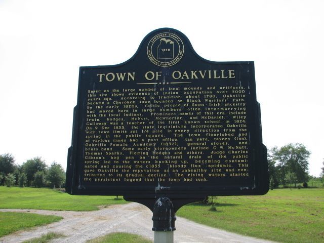
Town of Oakville
Based on numerous local mounds and artifacts, this site shows evidence of Indian occupation dating back over 2,000 years. According to tradition, Oakville was founded in 1780 as a Cherokee town on the Black Warrior's Path. By the early 1820s, Celtic people of Scots-Irish ancestry had moved here in large numbers, often intermarrying with the local Indians. Prominent names of this era included Irwin, Hodges, McNutt, McWhorter, and McDaniel. Wiley Galloway was a teacher at the first known school in 1824. On December 9, 1833, the state legislature incorporated Oakville with town limits set 1/4 mile in every direction from the spring in the public square. The town flourished and, at various times, had a post office, a tan yard, a tavern (Inn), Oakville Female Academy (1837), general stores, and a brass band. Some early store owners included G. W. McNutt, Thomas Sparks, Fleming Hodges, and others. Judge Charles Gibson's hog pen on the natural drain of the public spring led to the waters backing up, becoming contaminated, and causing the 1855 "bloody flux" epidemic. This gave Oakville its reputation as an unhealthy site and contributed to its gradual decline. The rising waters started the persistent legend that the town had sunk. |
 |
Multi-Cultural Indian Events Welcome
The Oakville Ceremonial Woodland Mound is the largest Indian mound at Oakville, covering some 1.5 acres of land and rising some 27 feet high. Believed to have served as a cultural center during the Woodland Period of North Alabama, the Oakville Ceremonial Woodland Mound is the largest in the State of Alabama.
The mound is estimated to have been built during the Woodland Period, which covered a period from 1,000 B.C. to 1,000 A.D. The mound was made one basketful of dirt at a time.
Stone spades were used to dig the soil from borrow pits and transfer it by baskets to the mound site.
The probable burrow pit was the depression that now contains Oakville Pond, the body of water northeast of the mound.
The only known modifications to the Oakville Ceremonial Woodland Mound are from cutting off a lower portion of the sides to provide more area for farming. In addition, the top of the mound has been repeatedly plowed, making the top edge steeper and possibly flatter.
The steps on the side of the mound were placed in an old roadbed leading to the top of the mound.
The Oakville area was considered a religious center and social complex of the Middle Woodland Indian people with outlying villages and farms. Additional Copena mounds located nearby support the complex social center theory.
The Copena people lived during this period from 1,000 B.C. to 1,000 A.D. Their society did not extend much farther south than the Warrior Mountains, which can be seen to the south of the Ceremonial Mound, or north to the Hogohogee (Tennessee) River, also known as the "River of Cherokees".
|
 |
Copena Burial Mound
Copena Indians built this mound with baskets of dirt some 2000 years ago. The Copena name derives from their use of copper and galena (lead ore) found in their burials, along with gorgets and celts. The mounds were burial sites, with the dead encased in a clay plaster, covered with layers of soil. The many burial mounds within a few miles of each other are evidence of an extensive cultural center. The perennial springs and fertile lands along West Flint Creek supported a large population. The Copena society flourished here for hundreds of years, and they raised a variety of domesticated crops. Some 17 miles north of the Tennessee River provided an inexhaustible food supply of freshwater mussels. In the mid-1800s, settlers were buried in the mounds under false stone crypts. In 1924, Smithsonian archaeologists noted three other burial mounds in areas being leveled by farmers.s |
 |
| Indian Mound |
 |
Historic Indians
Five Historic Indian tribes lived in this area. By 1701, the Yuchi were residing at the shoals on the Tennessee River. In the early 1700s, the Yuchi left, some moving to the Cherokee Nation on the Hiwassee River in TN, and others to the Chattahoochee River in GA. After a dispute with the Cherokee, some Yuchi moved south to the ALGA border. Although some Creeks lived in the area by the late 1700s, their lands lay south of the Tennessee Divide. The Treaty of Fort Jackson took Creek lands in southern Lawrence County in 1814. The Shawnees moved from the Cumberland and Ohio Rivers to the shoals. Leftwich (1935) says the Chickasaws and Cherokees forced the Shawnees from the Tennessee Valley in 1721. By 1760, Chickasaws moved into the Tennessee Valley from the west. The Chickasaw Boundary Treaty (January 10, 1786) gave Chickasaws ownership of the area. In 1769, Cherokees challenged the Chickasaw in the Battle of Chickasaw Oldfields south of Huntsville. By 1770, Cherokees were established in Lawrence County. The Chickasaws and Cherokees lived in peace within the Tennessee Valley until the Turkey Town Treaty of 1816 mandated their removal. Today, descendants of the Creeks, Cherokees, and Chickasaws, among others, live in Lawrence County. |
 |
Doublehead
Doublehead (c1744-1807), aka Dsugweladegi or Chuqualatague, was the son of Great Eagle (Willenawah) and grandson of Moytoy. Among his siblings were Pumpkin Boy, Old Tassel, and the unnamed grandmother of Sequoyah. After his sister's son, John Watts Jr., was elected chief over him, Doublehead moved to Lawrence County and became an influential Cherokee leader. While living at Browns Ferry from c1790~c1802, the head of the Elk River Shoals, Doublehead, terrorized settlers on the Appalachian frontier until his 1794 meeting with George Washington. By treaty on January 1,0, 1786, most of Lawrence County became Chickasaw land. Doublehead was permitted to stay because of his daughters' (Tuskihooto and Saleechie) marriages to Chickasaw Chief George Colbert. Learning of the wealth in cotton, Doublehead in 1802 petitioned the government for a keelboat, signed the 1805 treaty authorizing Gaines Trace, and negotiated the 1806 Cotton Gin Treaty. This treaty placed a cotton gin at Melton's Bluff and gave him a 99-year lease on Doublehead's Reserve between Elk River and Cypress Creek. In partnership with John D. Chisholm, they leased this reserve to settlers. On August 9, 1807, Major Ridge, Alex Saunders, and John Rogers killed Doublehead, either for control of the cotton trade or for his ceding of Indian Lands. |
 |
Saunders~ Hall~ Goode Mansion
This mansion, located about one mile east, was placed on the National Register of Historic Places in October 974. Built by Turner Saunders (1782-1853) on property purchased on April 9, 1833, the house may have been constructed earlier. Revolutionary War Veterans Thomas Saunders and Ann Turner were his parents. Turner was born in VA and, in 1821, moved with his first wife, Francis (Dunn), to Lawrence County. After she died in 1824, Saunders married Henrietta Millwater on July 1, 1826. Considered an excellent example of Palladian design, the two-story mansion with a brick basement has been likened to a Greek temple. Saunders, a noted Methodist preacher, was elected (1830) the first president of LaGrange College, some 10 miles to the southwest. On April 28, 1863, Gen. GM Dodge's Union soldiers burned this school (the 1st state-chartered Al College). On February 12, 1844, Saunders sold the house to Freeman Goode and relocated to Aberdeen, MS, where he died in 1853. Later owners included the Hall and Skeggs families. Turner's son, James E. Saunders, author of the first significant history of Lawrence County, was an aide and personal friend of Gen. Nathan B. Forrest. James E. built a plantation house, known as Rocky Hill Castle, in c1860, some 4 miles south of this site. |
 |
| The Saunders~ Hall~ Goode Mansion needs restoration |
Our last stop was at the Saunders~ Hall~ Goode Mansion in Lawrence County.
Hubby and I had a great day visiting the sites of Morgan County, Alabama.


